Sale!


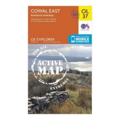


Explorer Active OL37 Cowal East Dunoon & Inveraray Map With Digital Version
Original price was: £9.60.£6.72Current price is: £6.72.
- Free Shipping over £25
- SSL encryption, absolutely safe shopping
- Quality products for every lifestyle.
- Quality You Can Count On

The Active Explorer OL 37 is a detailed weatherproof map which covers Cowal East, Dunoon and Inveraray, and replaces the previous OS Explorer map 363 for this area. Covering a large section of Loch Lomond and The Trossachs National Park, this map allows you to discover the many trails and points of interest which make this area worth exploring.
- Detailed and informative explorer map of Cowal East from Ordnance Survey
- Covers Loch Lomond, The Trossachs National Park, Argyll Forest Park, Kyles of Bute, Loch Fyne, Holy Loch and West Island Way
- Scale: 1:25000
- Now includes Mobile Download
- Active weatherproof version
- Recommended activity – walking / hiking / cycling / navigation / expedition
| Choose size in stock | One Size |
|---|
Be the first to review “Explorer Active OL37 Cowal East Dunoon & Inveraray Map With Digital Version”
Related products
Sale!


Walking
Original price was: £299.97.£95.99Current price is: £95.99.
Sale!


Walking
Original price was: £6.00.£4.20Current price is: £4.20.
Sale!
Original price was: £6.00.£4.20Current price is: £4.20.
Sale!

Original price was: £9.60.£6.72Current price is: £6.72.
Sale!


Walking
Original price was: £39.00.£27.30Current price is: £27.30.
Sale!
Original price was: £9.60.£6.72Current price is: £6.72.
Sale!


Original price was: £2.20.£1.54Current price is: £1.54.
Sale!
Original price was: £6.00.£4.20Current price is: £4.20.
Reviews
There are no reviews yet.